


Throughout it's history, the Cofrin Center for Biodiversity at the University of Wisconsin-Green Bay has served as a clearinghouse for imagery documenting the natural communities and natural history of the Western Great Lakes. This website is intended to raise awareness of the resources that are available and to improve access to the image files.
As part of its work in the region, the Biodiversity Center has custody of several collections of historic prints and slides. In 2015, the CCB proposed an effort to stop the loss of information due to ongoing deterioration of the originals and to make the information more available for researchers. The key components of the project are:
Efforts to get the project off the ground received a major boost from the Fox-Wolf Watershed Alliance. FWWA allocated $29,000 in Great Lakes Observing System (GLOS) funding to the Biodiversity Center in 2016 and the first half of 2017. The scanning and cataloging work performed under the contract with FWWA has protected a large cache of important information from loss and improved its availability to researchers.
|
Collection P002 consists of 866 slides documenting the state of Green Bay coastal wetlands over time. It includes aerial photos and ground level images from multiple sources. The collection was assembled by UW-Green Bay emeritus faculty members H.J. “Bud” Harris and Gary Fewless. |
|
Collection P003 consists of 874 slides documenting the status of wetlands and riverine systems in the region, containing both oblique aerial and ground photos. The collection is the work of former UW-Green Bay Herbarium Curator, Gary Fewless. |
|
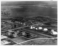
Collection P005 consists of 3587 vertical air photos used by the United States Army Corps of Engineers in support of their regulatory work on western Lake Michigan. Coverage includes harbors, shorelines and navigable tributaries. The great majority of the mages were acquired in Spring of 1976, when Great Lakes water levels were unusually high. |
|
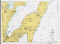
Collection P007 consists of 96 scanned paper maps from a number of sources and dates. Green Bay and Lower Fox River nautical charts account for the bulk of the content. |
| Collection P008 consists of nineteen prints documenting the state of the Fox River and Lower Bay from the 1920s thru the 1960s. The collection is the work of Richter Museum Curator Tom Erdman. |
In the last several years, a number of extremely valuable air photo acquisition projects have taken place in the region. The Biodiversity Center has an interest in making these resources as accessible as possible, regardless of the entity that "owns" them. Source files are availble for non-commercial use only. Normal practices regarding ownership and attribution apply.
 |
Bay Lake RPC - 2015 consists of 759 oblique air photos acquired in Fall of 2015. The aerial survey, which was focused on gathering Phragmites occurrence data, was part of Bay-Lake Regional Planning Commission's ongoing restoration planning work. See the footprint map at left. Acquisition and processing of the imagery was performed by Applied Ecological Services under a contract with BLRPC. |
 |
Biodiversity Center AIS - 2017 consists of 210 oblique air photos acquired in Fall of 2017. The aerial survey, which was focused on gathering Phragmites occurrence data, was part of the Biodiversity Center's ongoing restoration planning work. See the footprint map at left. Acquisition and processing of the imagery was performed by Applied Ecological Services under a contract with UW-Green Bay. |
 | Collection P001 consists of 1300 shoreline oblique photos covering the Green Bay shore from Oconto to the City of Green Bay to Sturgeon Bay. The source of the P001 collection is a group of 10,000 or so images acquired by the US Army Corps of Engineers in April, 2012.  |
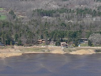 |
Collection P006 consists of 1597 shoreline oblique air photos acquired in Spring, 2008. It's a "Green Bay only" subset of a much larger collection created by the Wisconsin Coastal Management Program under their Wisconsin Shoreline Inventory project. The P006 version of the collection includes corrected photopoint mapping data where problems with positional accuracy of the source collection have been detected.  |